After the Storm
Rice’s SSPEED Center and the University of Texas at Arlington’s Water Engineering Research Center are designing a flood warning system for the Texas Hill Country in hopes that it can save lives.
By Alex Becker
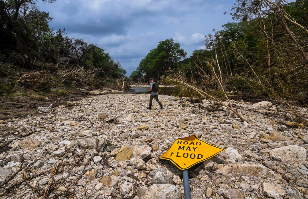
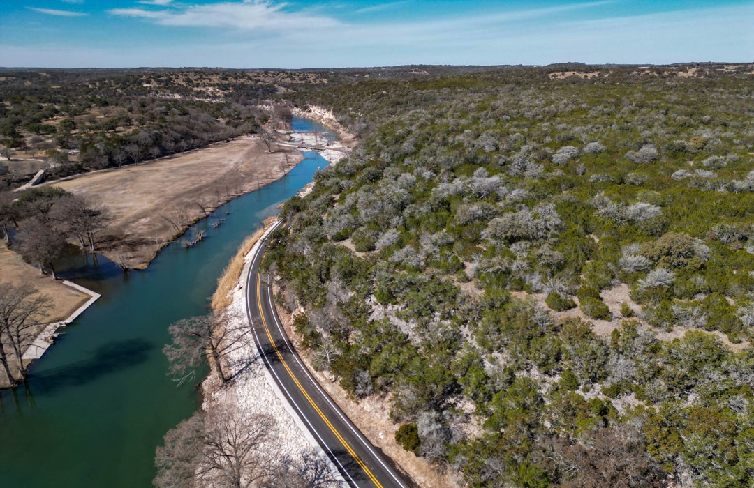
In the early hours of July 4, 2025, a storm system supercharged by tropical moisture stalled over Central Texas. Rain fell in sheets over the rolling landscape of the Texas Hill Country, a region beloved by generations of Texans for its clear water eddies, aquifer-fed pools and sprawling live oak trees.
But this same landscape is why the region is also known as Flash Flood Alley: thin soils over limestone rock absorb little rainfall, and steep slopes rapidly channel water downhill, producing sudden floods.
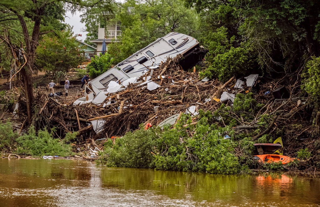
Along the Guadalupe River in Kerr County, water rose that night with terrifying speed. In some places, it climbed more than 20 feet in just a few hours. Near Hunt, where the river’s north and south forks merge, it crested at 37.5 feet. Homes splintered. Roads disappeared. People awoke to water surrounding them in their beds.
By the time daylight arrived, it was clear that the losses would be devastating. Officials would eventually count more than 130 people killed in the floods, among them 25 young girls and two teenage counselors at a local summer camp. In the days that followed, the familiar post-catastrophe questions surfaced: How could this happen? Who knew what, and when? Why didn’t the warnings reach people? And could the outcome have been different?
One answer was as blunt as it was painful: Kerr County did not have a dedicated flood warning system, despite prior proposals from local officials who had long cited the region’s high flood risk. The night the Guadalupe rose, communication failures compounded the disaster, made worse by a patchwork of dead zones and lost signals in a landscape where cell service can vanish in a curve of the road.
“During the July 4 event, there was essentially no localized flood intelligence reaching people on the ground,” says Philip Bedient, the director of Rice’s Severe Storm Prediction, Education and Evacuation from Disasters Center. “Rain was happening, but there wasn’t a system in place to translate that rainfall into clear, actionable warnings for specific locations. Our focus now is making sure that doesn’t happen again.”
Now a coalition of Texas universities is working to build the kind of warning infrastructure that many locals assumed already existed. The Hill Country Flood Early Warning System, or FEWS, will be tailored to the region and designed to translate rainfall into life-or-death decisions even before the precipitation begins.
No forecasting system can reverse the tragedy that unfolded along the Guadalupe last July. It cannot return lives lost or rebuild what was swept away. But it can alter what happens when the next storm forms.
The Texas governor’s office awarded $4 million to the University of Texas at Arlington to lead the project, with Rice University participating as a sub-awardee. The grant supports enhanced atmospheric measurement and modeling techniques to improve forecasting accuracy, strengthen weather intelligence and advance disaster preparedness across Texas. That money will fund the development and deployment of FEWS, the management of instruments collecting data, and crucially, the training of local leaders and emergency responders.
“We don’t just train scientists,” says Nick Fang ’08, head of the Water Engineering Research Center at the University of Texas at Arlington. “We train people who interpret flood warning information and deal with emergencies, like making the call at 2 a.m. to close roads and evacuate facilities.”
Supporting the flood warning system’s development and training efforts is Rice’s SSPEED Center, which has been preparing for storms for decades. In partnership with WERC, SSPEED will help develop a computer modeling system and floodplain map library that underpins the operational warning platform.
The SSPEED Center’s vision is ambitious: to lead in research and education on strategies to protect Texans from inland flooding and coastal surges, including comprehensive plans for surge protection along Galveston Bay.
When people talk about flood warnings, they often picture a siren or a text alert, but what SSPEED is designing starts much earlier, providing one to three hours of advance warning of a flood. It’s a framework that can take radar-derived rainfall data, run it through hydraulic and hydrologic models to predict future water depths at specific locations, and relay those predictions to emergency officials and communities while there is still time to act — and save lives in the process.
It is not a brand-new idea. SSPEED has already built and refined a version of this approach in Houston — specifically, around the Texas Medical Center, one of the most flood-prone and high-stakes locations in Texas.
For more than 20 years, SSPEED’s technology has monitored rainfall and response in watersheds like Brays Bayou to protect the medical center. In 2020, SSPEED helped develop the Flood Information and Response System for the city of Houston, an end-to-end, radar-based flood assessment and mapping tool meant for critical infrastructure, including hospitals, nursing homes, fire stations and shelters. FIRST allows users to see real-time visualizations of flooding hotspots and inundated areas during rain events, supporting emergency closures, evacuations and rescue operations.
In the Hill Country, the SSPEED Center will interpret advanced stream gauges at various locations in addition to the radar rainfall data. These measurements will feed into an integrated framework managed by WERC, strengthening accuracy and ensuring continuous system performance during fast-moving storm events.
In Houston, the large, mostly flat urban watershed offers a healthy amount of lead time, Bedient says, but in the Hill Country, the window for emergency operations is narrower. That time pressure means the warning system has to be fast, automated and easy to interpret.

In a perfect world, a computer model would take real-time data on the amount of rainfall falling over a river basin, run a full hydraulic simulation and output precise predictions of water depth across the region, instantly. But for an area like the Hill Country, that method is not practical or realistic during a fast-moving storm.
“That’s why we create the floodplain map library,” Bedient says. “In the midst of a storm, when you’re getting unleashed with rain, you don’t have time to sit there and have a particular individual making data runs while the rain is happening. With our system, those runs have all been made ahead of time.”
Instead of running enormous models live during a storm, the team precomputes a “library” of flood scenarios in advance. Then, when storms arrive, the system matches the current rainfall pattern to the closest pre-modeled scenario and displays the corresponding inundation maps immediately. WERC will operationalize this library within a decision-support interface designed for use by local officials during active emergencies.
The basis for this modeling is something called HEC-RAS — the River Analysis System developed by the U.S. Army Corps of Engineers’ Hydrologic Engineering Center. The tool has existed in various forms since the 1960s, and WERC and the SSPEED Center are working with the latest HEC-RAS generation, alongside a model built by the state of Texas and other partners that serves as a starting point.
The immense scale of the Hill Country demands fine-grained modeling. To capture the complexity of the terrain, the team will divide a region of more than 1,000 square miles into a grid of cells just under an acre each. The model then translates rainfall into water flow and surface elevations across an immense number of points, allowing researchers to simulate how floods move across the landscape.
The FEWS framework does not treat rainfall as uniform. The Hill Country is hydrologically diverse, and storms rarely distribute rain evenly across its terrain, creating spatial differences that can heavily influence flood behavior.
To account for that variability, researchers are simulating a wide range of rainfall scenarios, from 4 inches to as much as 18 inches in a single day distributed across different parts of the watershed. Each configuration will produce a distinct inundation pattern.
The SSPEED Center will ultimately generate about 125 of these flood inundation maps, forming a precomputed library of realistic storm outcomes. As weather radar provides new updates every five to 15 minutes, the system will evaluate where rain is falling and how intensely, and then select the map that most closely matches current conditions.
In this framework, radar serves as the system’s real-time vision, continuously tracking storms as they develop and move across the basin.
“The radar is remarkably accurate,” Bedient says, explaining that the technology measures precipitation in the atmosphere and calculates how much rainfall is actually reaching the ground. Rather than relying on assumptions or delayed reports, the system observes conditions as they unfold and then uses the library to convert those measurements into clear, color-coded anticipated flood maps designed to support rapid decision-making.
Those visualizations allow emergency managers to quickly interpret evolving threats, anticipate where flooding is likely and respond before conditions worsen. The overarching objective, Bedient emphasizes, is to provide communities with one to two hours of advance warning of potential flash floods.
“When a storm hits, you don’t have time to wait for a model to finish running,” says Fang. “The system instantly matches live radar rainfall to the closest pre-modeled scenario, so users can see flooding impacts almost immediately.”
The program is also working in close collaboration with another project led by Texas Tech University, which was awarded a $24 million grant by the state to install additional weather stations along with two new radar systems in the region. Expanded radar coverage will sharpen the rainfall picture across the Hill Country. Fang and Bedient’s teams are also collaborating with environmental engineer Jacob Torres ’16 of Torres & Associates, who will manage gauges and sensors to confirm model predictions and improve system accuracy over time. Together, these efforts will form a high-resolution monitoring and forecasting network centered in Texas and built specifically for Texas watersheds.
Notably, both Fang and Torres received their doctorate degrees from Rice, studying under Bedient.
“Gaining experience on flood warning and disaster mitigation with Bedient was inspiring and rewarding,” Fang says, explaining that it was his time at Rice that set his career interest in developing flood early warning systems to save people’s lives and minimize damage from disasters.
FEWS represents a Texas-built response to a distinctly Texan challenge, a reality that carries weight in a state long shaped by cycles of flood and recovery. Communities have always clustered near water, drawn by beauty, opportunity and growth, even as history shows how quickly those waters can turn destructive. Disasters arrive with force, recede and, too often, fade from public memory until the next storm revisits the lesson.
No forecasting system can reverse the tragedy that unfolded along the Guadalupe last July. It cannot return lives lost or rebuild what was swept away. But it can alter what happens when the next storm forms. It can render risk visible before rivers rise, transforming uncertainty into actionable information. It can give local officials the confidence to act earlier and residents the time to move out of harm’s way. And in that margin, measured not in data points, but in minutes and decisions, systems like FEWS hold the potential to change the future.
Philip Bedient is the Herman and George R. Brown Professor of Engineering in the George R. Brown School of Engineering and Computing at Rice.
What the SSPEED Center Does
Established in 2009 as a university-based research and education center, the Severe Storm Prediction, Education and Evacuation from Disasters Center at Rice University advances research and practical solutions to reduce the Gulf Coast’s vulnerability to severe storms, flooding and coastal surge. Its work integrates engineering, nature-based approaches and predictive technologies to strengthen regional resilience. The center also convenes experts and decision-makers through workshops and conferences and partners with government, industry and community organizations to translate science into real-world risk-reduction strategies.
Flagship Initiatives
Galveston Bay Park Plan
An innovative regional solution that pairs coastal protection with public and environmental benefits, the Galveston Bay Park Plan proposes a system of engineered barriers and parkland across Galveston Bay to significantly reduce hurricane storm surge risk while enhancing navigation, recreational access and natural habitats — complementing broader federal protection plans.
Flood Warning and Response Systems
The SSPEED Center develops advanced real-time flood warning tools, including the Flood Information and Response System — a radar-based forecasting and mapping platform that continuously ingests rainfall and watershed data to predict inundation and warn emergency managers and critical infrastructure operators hours before flooding occurs. FIRST supports planning and response across major Houston watersheds and helps decision-makers determine when to close roads, evacuate or protect facilities during heavy rain events.
Nature-Based Carbon Credit Research and Programs
SSPEED is advancing nature-based carbon credit systems that link ecological stewardship with climate and flood resilience. This includes research to develop monitoring, reporting and verification systems for carbon credits and to evaluate nature-based practices (like coastal wetland and prairie restoration) that sequester carbon while contributing to flood protection and watershed health.
From the Spring 2026 issue of Rice Magazine